WISKUNDIGE GELETTERDHEID
GRAAD 11
NOG OEFENINGE
Kaarte en reise
GRAAD 11
NOG OEFENINGE
Kaarte en reise
MATHEMATICAL LITERACY
GRADE 11
MORE EXERCISES
Maps and trips
GRADE 11
MORE EXERCISES
Maps and trips
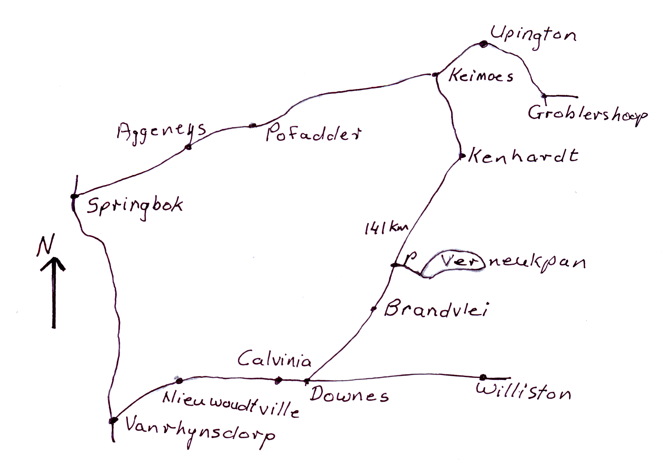
In 1929 was die landspoedrekord
200 myl per uur, 200 mph.
Sir Malcolm Campbell kom na Verneukpan in
die Noord-Kaap om die rekord te verbeter.
Intussen is die rekord verbeter na 231,36 mph.
Campbell wou 'n spoed van 300 mph bereik.
Hy slaag egter nie daarin nie.
Beskou die kaart hierbo en gebruik dit
om die vrae te beantwoord :
1.1 Beskryf die roete vanaf Upington na
Verneukpan.
[ A 1.1 ]
1.2 Die werklike afstand vanaf Kenhardt na
Brandvlei is 141 km. Die afstand op die
kaart is 14,1 cm. Toon aan dat die skaal
van die kaart is 1 : 1 000 000. Toon alle
nodige berekeninge.
[ A 1.2 ]
1.3 Skakel 300 mph om na km/h, tot die
naaste heelgetal.
Gegee dat 1 myl = 1,60934 km.
[ A 1.3 ]
1.4.1 Toon aan dat dit 12 sekondes neem
om 1 myl teen 'n spoed van
300 mph te ry.
Jy kan die volgende gebruik :
afstand
spoed = ───────
tyd
[ A 1.4.1 ]
1.4.2 Teen watter spoed, in km/h,
ry hy as dit 12 sekondes neem
om 1 km af te lê?
[ A 1.4.2 ]
1.5 Tom wil vanaf Pofadder na Verneukpan
vlieg.
1.5.1 In watter algemene rigting moet hy
vlieg?
[ A 1.5.1 ]
1.5.2 Die afstand op die kaart is 158 mm.
Hoe ver is Pofadder vanaf
Verneukpan?
[ A 1.5.2 ]
1.5.3 Hy vertrek om 08:15 vanaf Pofadder
en land om 09:05 op Verneukpan.
Hoe lank, in uur, het hy gevlieg?
[ A 1.5.3 ]
1.5.4 Bereken die spoed waarteen hy
gevlieg het.
[ A 1.5.4 ]
In 1929 the landspeed record was
200 miles per hour, 200 mph.
Sir Malcolm Campbell came to Verneukpan in
the Northern Cape to improve on the record.
Meanwhile the record was improved to
231,36 mph. Campbell wanted to reach a speed
of 300 mph. Unfortunately he did not succeed.
Study the map above and use it
to answer the questions :
1.1 Describe the route from Upington to
Verneukpan.
[ A 1.1 ]
1.2 The actual distance from Kenhardt to
Brandvlei is 141 km. The distance on the
map is 14,1 cm. Show that the scale of
the map is 1 : 1 000 000. Show all the
necessary calculations.
[ A 1.2 ]
1.3 Convert 300 mph to km/h, to the
nearest whole number.
Given that 1 mile = 1,60934 km.
[ A 1.3 ]
1.4.1 Show that it takes 12 seconds to
travel 1 mile at a speed of
300 mph.
You can use the following :
distance
speed = ───────
time
[ A 1.4.1 ]
1.4.2 At what speed, in km/h, does he
drive if it takes 12 seconds to
cover 1 km?
[ A 1.4.2 ]
1.5 Tom wants to fly from Pofadder to
Verneukpan .
1.5.1 In which general direction must he fly?
[ A 1.5.1 ]
1.5.2 The distance on the map is 158 mm.
How far is Pofadder from
Verneukpan?
[ A 1.5.2 ]
1.5.3 He departs at 08:15 from Pofadder
and lands at 09:05 on Verneukpan.
How long, in hours, did he fly?
[ A 1.5.3 ]
1.5.4 Calculate the speed at which he flew.
[ A 1.5.4 ]
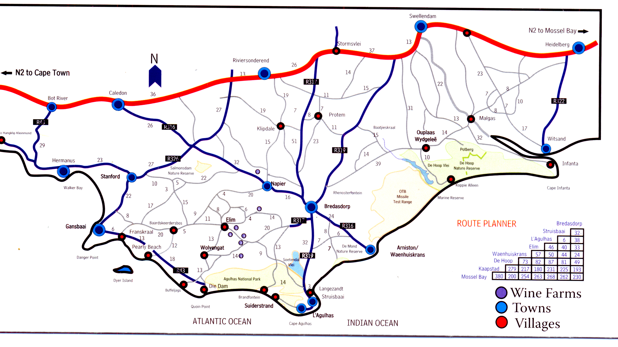
Kaart verkry van pamflet ..discover Cape Agulhas / Map abtained from pamphlet ..discover Cape Agulhas
Bestudeer die kaart hierbo en beantwoord
dan die volgende vrae :
2.1 Beskryf die roete vanaf Die Dam
na Caledon.
[ A 2.1 ]
2.2 Hoe ver is Napier van Calecon?
[ A 2.2 ]
2.3 Op die kaart is die afstand vanaf
Napier na Caledon 50 mm. Bepaal
die skaal van die kaart.
[ A 2.3 ]
2.4 Die afstand van Gansbaai na
Stanford is 22 km. Bepaal die
afstand op die kaart.
[ A 2.4 ]
2.5 Wat is die algemene rigting
vanaf L'Agulhas na Stanford?
[ A 2.5 ]
2.6 Gebruik die Route Planner op
die kaart om te bepaal hoe ver is
2.6.1 Mosselbaai van Kaapstad.
[ A 2.6.1 ]
2.6.2 Waenhuiskrans van Struisbaai.
[ A 2.6.2 ]
Study the map above and use it
to answer the questions :
2.1 Describe the route from Die Dam
to Calecon.
[ A 2.1 ]
2.2 How far is Napier from Calecon?
[ A 2.2 ]
2.3 On the map the distance from Napier
to Caledon is 50 mm. Determine
the scale used on the map.
[ A 2.3 ]
2.4 The distance from Gansbaai to
Stanford is 22 km. Determine the
distance on the map.
[ A 2.4 ]
2.5 What is the general direction
from L'Agulhas to Stanford?
[ A 2.5 ]
2.6 Use the Route Planner on the map to
to determine the distance from
2.6.1 Mossel Bay to Cape Town.
[ A 2.6.1 ]
2.6.2 Waenhuiskrans to Struisbaai.
[ A 2.6.2 ]
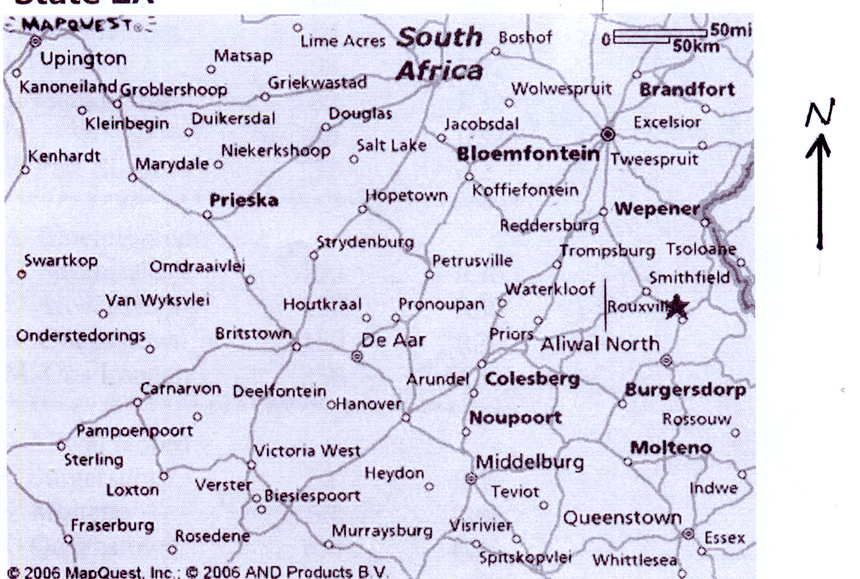
Bestudeer die kaart hierbo en beantwoord
dan die volgende vrae :
2.1 Beskryf die roete vanaf Carnarvon
na Bloemfontein. Gee die name van
die dorpe waarlangs jou roete loop.
[ A 3.1 ]
3.2 Die afstand van Hopetown na
Strydenburg is 55 km. Op die kaart
is hierdie afstand 11 mm. Bereken
die skaal op die kaart in die
formaat 1 : .....
[ A 3.2 ]
3.3 Op die kaart is die afstand van
Prieska na Britstown 2,6 cm.
Bereken die werkilike afstand
van Prieska na Britstown.
[ A 3.3 ]
3.4 Wat is die algemene rigting vanaf
Prieska na Middelburg?
[ A 3.4 ]
3.5 Regs bo op die kaart sal jy 'n
skaal sien. Wat word hierdie tipe
skaal genoem? [ A 3.5 ]
Study the map above and use it
to answer the questions :
3.1 Describe the route from Carnarvon
to Bloemfontein. Give the names of the
towns through which your route passes.
[ A 3.1 ]
3.2 The distance from Hopetown to
Strydenburg is 55 km. On the map this
distance is 11 mm. Calculate the scale
of the map in the format 1 : .....
[ A 3.2 ]
3.3 On the map the distance from Prieska
to Britstown is 2,6 cm. Calculate the
real distance from Prieska to Britstown.
[ A 3.3 ]
3.4 What is the general direction from
Prieska to Middelburg?
[ A 3.4 ]
3.5 At the right top on the map you will
find a scale. What is this type of
scale called? [ A 3.5 ]
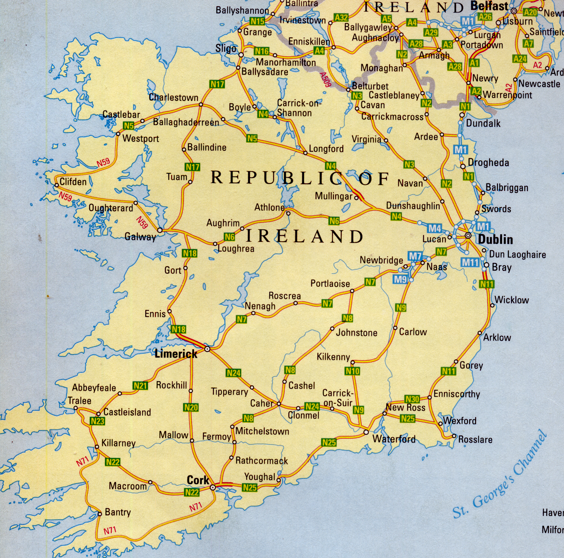
Bestudeer die kaart van die Republiek van
Ierland hierbo en beantwoord dan die
volgende vrae :
4.1 Describe the route from Cork to
Ballysadare. Give the names of the
towns through which your route passes
as well as the route names.
[ A 4.1 ]
4.2 What is the general direction of
Waterford from Dublin?
[ A 4.2 ]
4.3 On the map the distance from Cashel
to Johnstone is 17 mm. The actual
distance is 25 miles. What is the
scale of the map?
[ A 4.3 ]
4.4 The actual distance from Cork to
Limerick is 42 miles. What is
the distance on the map?
[ A 4.4 ]
4.5 Convert 25 miles to km if
1,60934 km = 1 mile.
[ A 4.5 ]
4.6 Beneath the map is a scale.
What is this scale called?
[ A 4.6 ]
Study the map of the Republic of Ireland
above and use it to answer the questions :
4.1 Describe the route from Cork to
Ballysadare. Give the names of the
towns through which your route passes
as well as the route names.
[ A 4.1 ]
4.2 What is the general direction of
Waterford from Dublin?
[ A 4.2 ]
4.3 On the map the distance from Cashel
to Johnstone is 17 mm. The actual
distance is 25 miles. What is the
scale of the map?
[ A 4.3 ]
4.4 The actual distance from Cork to
Limerick is 42 miles. What is
the distance on the map?
[ A 4.4 ]
4.5 Convert 25 miles to km if
1,60934 km = 1 mile.
[ A 4.5 ]
4.6 Beneath the map is a scale.
What is this scale called?
[ A 4.6 ]
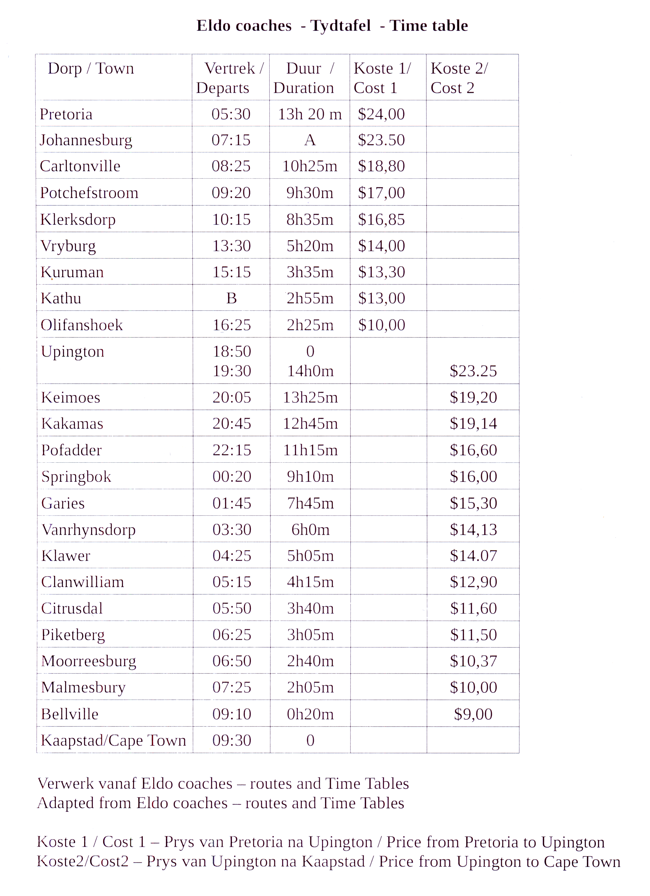
Jack en Jill kom van die VSA om vriende in
Upington en Kaapstad te besoek.
Hulle besluit om die Eldo bus vanaf
Johannesburg na Upington en dan later
van Upington na Kaapstad te neem.
Bestudeer die tydtafel va Eldo Coaches
hierbo en beantwoord dan die
volgende vrae :
5.1 Bereken die waardes van A en B
in die tabel.
[ A 5.1 ]
5.2 Hoe laat het Jack en Jiil die Eldo
bus van Johannesburg geneem?
[ A 5.2 ]
5.3 Wat is die prys van 'n kaartjie
van Johannesburg na Upington
VSA dollar? Hoeveel dollar het
hulle vir twee kaartjies betaal?
[ A 5.3 ]
5.4 Skakel $47,00 om na Rand
as $1 = R14,85
[ A 5.4 ]
5.5 Hoe lank die duur die rit van
Johannesburg na Upington?
[ A 5.5 ]
5.6 Wat is gie gemiddelde spoed van die bus
bus as die afstande van Johannesburg
na Upington 880 km is?
Jy mag die volgende gebruik
afstand
spoed = ───────
tyd [ A 5.6 ]
5.7 By Potchefstroom klim John, 'n vriend
van Jack en Jill ook op die bus. Die
prys, in dollar, van 'n enkelkaartjie van
Potchefstroom na Upington is $16,23.
John het R259,25 vir die kaartjie betaal.
Bereke die wisselkoers op die dag
toe John die kaartjie gekoop het.
[ A 5.7 ]
5.8 Jack en John stry oor die spoed van
van die bus terwyl dit van
Olifantshoek na Upington ry.
John beweer dat die bus teen
ongeveer 80 km/h ry. Jack beweer
dat die bus veel vinniger ry.
Die bus is in staat om teen
100 myl per uur te ry.
5.8.1 Skakel 100 myl per uur (mph)
om na km/h. Jy mag die volgende
gebruik : 1 mph = 1,60934 km/h
[ A 5.8.1 ]
5.8.2 Hoe lank duur die rit van
Olifantshoek na Upington?
[ A 5.8.2 ]
5.8.3 Bereken die spoed van die bus van
Olifantshoek na Upington as die
afstand 263 km is.
[ A 5.8.3 ]
Jack and Jill came from the USA to visit
friends in Upington and Cape Town.
They decided to take the Eldo coach from
Johannesburg to Upington and then later
from Upington to Cape Town.
Study the Eldo Coaches's time table
above and then answer the
following questions :
5.1 Calculate the values of A and B
in the table.
[ A 5.1 ]
5.2 At what time did Jack and Jill catch the
Eldo coach from Johannesburg?
[ A 5.2 ]
5.3 What is the price of a ticket from
Johannesburg to Upington in
USA dollars? How many dollar did
they pay for two tickets?
[ A 5.3 ]
5.4 Convert $47,00 to Rand if
$1 = R14,85
[ A 5.4 ]
5.5 What is the duration of the trip
from Johannesburg to Upington?
[ A 5.5 ]
5.6 What is the average speed of the bus
if the distance from Johannesburg to
Upington is 880 km?
You may use the formula
distance
speed = ───────
time [ A 5.6 ]
5.7 At Potchefstroom John, a friend of
Jack and Jill joins them on the bus.
The dollar price of a single ticket from
Potchefstroom to Upington is $16,23.
John paid R259,25 for the ticket.
Calculate the exchange rate on the
day when John bought the ticket?
[ A 5.7 ]
5.8 Jack and John are arguing about the
speed of the bus as it drives from
Olifantshoek to Upington.
John claims that the bus is driving
at about 80 km/h. Jack claims that
the bus is going much faster.
The bus is capable of driving
at 100 miles per hour.
5.8.1 Convert 100 miles per hour (mph)
to km/h. You may use the following :
1 mph = 1,60934 km/h
[ A 5.8.1 ]
5.8.2 What is the duration of the trip
from Olifantshoek to Upington?
[ A 5.8.2 ]
5.8.3 Calculate the average speed of the
bus from Olifantshoek to Upington
if the distance is 263 km..
[ A 5.8.3 ]